


By Stephen J. Kotz
East Hampton Town has an extensive trail network that makes its way through the woods at Barcelona Point all the way to the Montauk moorlands. But for years, the town has not had up-to-date maps to help hikers find their way.
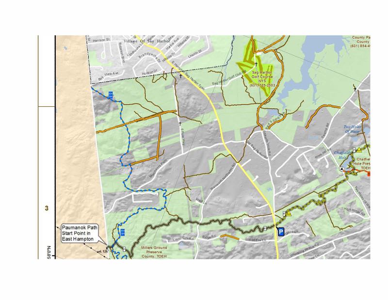
That changed last week when the East Hampton Town Board approved the printing of a set of two detailed maps, one for trails from Town Line Road east to Napeague Harbor, the other from the harbor to Montauk. They will be sold at the Town Clerk’s office at Town Hall on Pantigo Road in East Hampton.
The maps, which measure 27-by-42 inches, will cost $10 apiece or $15 for two, according to Bob Masin, who is director of the town’s Geographic Information System in the Information and Technology Department.
“They are small enough to use in the field but big enough for the details,” he said.
[caption id="attachment_54880" align="alignright" width="539"] A page from East Hampton Town's updated trail map.[/caption]
Mr. Masin said the town has had a law on the books for nearly a decade stating that the town would create a database of trails and update its map every five years. “It was something that didn’t get done,” he said. Several years ago, the project was handed over to the IT Department to organize the data.
“It’s something the public has really wanted,” said Mr. Masin, who has been working on the maps as a side project.
Although all the named trails are included as well as significant natural and historic features along their paths, Mr. Masin said, “we anticipate with the first release, we’ll get a lot of feedback and requests for more information. We went to the extent we could go, and more information will be added in the future.”
And while one might think all the trails have been accounted for, Mr. Masin said just last week, he discovered a small section of the Paumanok Path in Montauk that had not been included in the original map but has now been added.
Mr. Masin said the town has about 207 miles of trails, so he decided to split the information into two maps that provide a bit of overlap. “If we tried to fit everyone on one map, we would either create such an enormous map that you wouldn’t be able to use it in the field,” he said, “or if we went with a normal size map, we would have to lose all of the detail.”
Given that he works for the town’s IT Department, Mr. Masin said he is aware that many hikers might find paper maps a bit old fashioned. “We also plan on having something available that can be consumed on a laptop or mobile device within the next year,” he said.


 gavinmenu on Aug 24, 2016