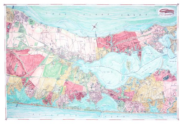
The maps that sell best are of places in which people take pride, or places that resonate with them in some important way.
“If it’s not where they live, either they fish or they boat or they hunt there,” said Joseph S. Tarella, the owner of Coastal Art Maps, who makes hand-drawn, watercolor maps of the East Coast—including two of Eastern Long Island, from Riverhead to Shelter Island, and from Shelter Island to Montauk, each map showing both forks, in keeping with his interest in where the water meets the land.
“I think it’s an amazing area in general,” the artist said. “But most of the time the North Fork and the South Fork are on different maps—I think the relationship between them is interesting.”
A commercial architect based in New York City, Mr. Tarella made a map of Battery Park City very early in his career. Then, when he built a house on Long Beach Island in New Jersey, around 2000, he couldn’t find a good map of the island.
“I like maps—whenever I travel I buy maps—and I couldn’t find a decent map,” he said. “Being it was a barrier island, a lot of things had changed.”
So Mr. Tarella put together one of his own, drawing upon road maps, nautical maps, maps of national parks, and maps by the U.S. Geological Survey.
“It took me almost a year to make,” he said of his map of Long Beach Island. “Every map is sort of ... about the thing it’s mapping—what its priorities are. I actually try to make the maps to be pretty accurate—that means not prioritizing one thing over the other.”
Mr. Tarella’s map of Long Beach Island took off, with acquaintances asking for ones of their own, and Mr. Tarella giving friends maps that showed their own homes as housewarming gifts. In his downtime he went on to painstakingly draw and watercolor about 35 more maps of other places on the East Coast—from Cape Cod to Key West to Georgica Pond, where he’s done some kayaking.
“It’s the opposite of what I do in my day job,” Mr. Tarella said, meaning that he doesn’t have to suit the demands of a particular client. “These are pieces of art, so I do what suits me—if you like it, buy it.”
People do demand authenticity, and although the maps are more works of art than travel tools, are quick to note if their own point of reference doesn’t look right, or if they disagree with how it is spelled. When they recognize a personal landmark, they’re “delighted,” Mr. Tarella said, and “when they don’t find it, they’re disappointed.”
He said he was surprised to find that his maps sell best not so much where there are more people, but “where people are proud of their place”—the Sea Islands of South Carolina, or Cape May, for instance.
One customer who’d sailed around Nantucket with his 13 grandchildren bought each of them a map of that area as a gift. “That was something that really resonated for him,” Mr. Tarella said. “I think people like something that they are really familiar with—I think those areas are really important to people.”
The maps cost about $160 for a 20-inch-by-30-inch one on watercolor paper, or $700 for a 40-inch-by-60-inch one on giclee canvas and can be found at coastalartmaps.com. Four are of sections of Long Island, showing its water bodies, beaches, parks and villages, that can be displayed collectively or individually.
“You really get to know a place if you map it thoroughly,” Mr. Tarella said. “It’s mostly been fun to do all of them, because each place is different, and you get to know it better when you work on it and stare at it for months. It’s just a really nice way to holistically look at a place.”