


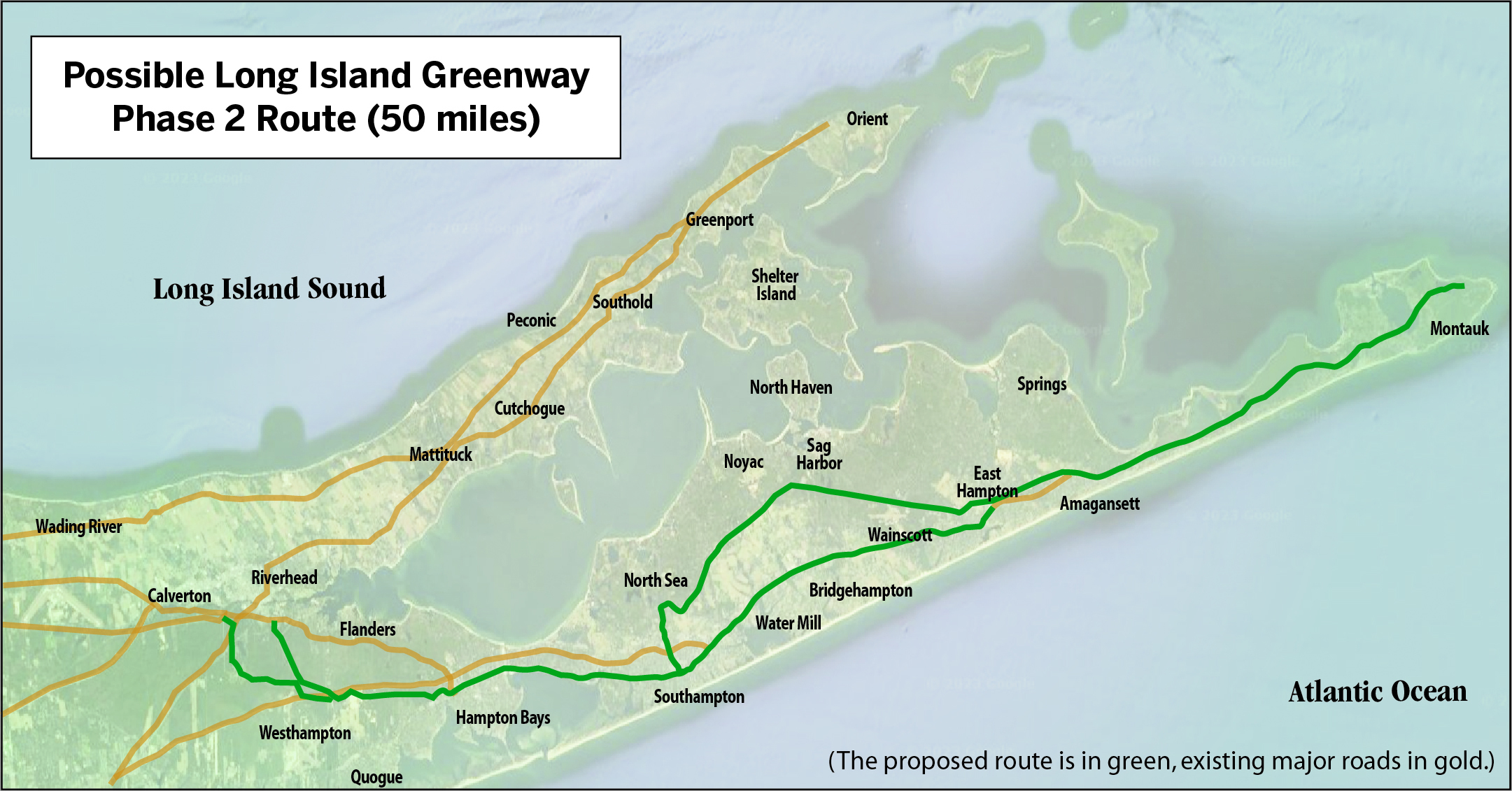
The map above depicts the South Fork leg of the Long Island Greenway, proposed to run from Manhattan to Montauk.
The Long Island Greenway, a planned multi-use path running from Manhattan to Montauk for bikers and walkers, could become this generation’s answer to the Long Island Expressway, advocates of the plan told local officials this week of the ambitious undertaking.
The local phase of the project would craft a greenway route running 50 miles from Riverhead to Montauk.
The project was spawned in 2017, when then-governor Andrew Cuomo announced plans to create the Empire State Trail, running from Buffalo to Manhattan, and from Plattsburgh to the city. The 350-mile trail was completed in just three years
“But they forgot Long Island,” Carter Strickland of the Trust for Public Land pointed out to members of the East Hampton and Southampton town boards this week.
Working with the state and Nassau and Suffolk counties, the Trust for Public Land conceived a path that would run 175 miles across Long Island, from Manhattan to Montauk. It would snake along roadsides and through parklands, jumping to trails through woodlands and public right-of-ways, linking public transportation hubs and hamlets and, hopefully, someday provide an actual viable alternative to the use of cars for travel between communities.
“The potential is pretty amazing,” Strickland told the East Hampton lawmakers on Tuesday. “It will complement existing road infrastructure. Short trips, one to three miles, will be easy on bikes and especially e-bikes.”
The first phase of the greenway will be a 25-mile section in the middle of the island, bridging Nassau and Suffolk counties, starting at Eisenhower Park in Bethpage and running to Brentwood State Park.
Designed to be 60 percent off-road, running along the Long Island Power Authority right of way, it connects 13 parks. Nine communities with estimated populations of 128,000 are directly on the trail. Some 36 schools and universities are located within a mile of Phase 1.
Final design work is expected to start in 2024 — the project has received more than $3 million in state and federal grants for the planning and design — with the project shovel-ready by 2025 at a completed cost of about $17 million.
Strickland said Phase 2, through the South Fork, won’t be far behind — designs and targeted planning should start in 2024.
Locally, the route would likely align with varied bike routes planned under Suffolk County’s Hike-Bike Master Plan.
The entire greenway is expected to cost $114 million. More state and federal grants are on the horizon. The federal government is eager to award grants for transportation projects with funding from the Infrastructure Investment & Jobs Act and the Inflation Reduction Act, Strickland said.
The deadline for the next round of grant funding is February 28, which Suffolk County will be spearheading. If federal funding is secured in the coming grant cycle, planning and design of the South Fork phase could be completed by June 2025. The planning and detailed design stage is expected to cost approximately $5 million over two years.
Strickland said some 80 percent of the funding, $4 million, is expected to come from federal sources. The balance requires a local match that could be provided by the state. He noted the state has already shown “strong support” through awarding grants totaling over $1 million for the first leg of the greenway.
Just in case the state doesn’t come through, Strickland said local commitments as backup are required. He’s asking Southampton and East Hampton towns to provide a funding commitment letter in the amount of $100,000, or $50,000 a year for two years, to support this effort in the event state funds cannot be secured.
“Finding ways to reduce traffic and improve connectivity along safe routes of travel for bicycles and pedestrians is right in our wheelhouse of things we’d like to see happen,” East Hampton Town Supervisor Peter Van Scoyoc said. “It’s something we’ve been looking at for a long time.”
The State Parks Department has made providing connections to the Empire State Trail a priority, Strickland said. A regional approach with support from local municipalities is “very compelling,” he said.
Southampton Town Supervisor Jay Schneiderman said he’d want an assurance that any allocation of town funds would be contingent on the failure of state funding to come through.
He was also concerned about possibly being on the hook for construction costs, which could be substantial. Strickland explained the money commitment requested would apply to the design phase alone. When the time comes for construction, another round of grants will be sought.
Southampton Councilman Tommy John Schiavoni wanted to know the extent to which community outreach will take place. There’s a whole engagement process, to make sure there’s buy-in, Strickland assured. He anticipates holding “scores of meetings” with the community, as well as making sure the plans reflect existing town and village plans. Schneiderman pointed out that officials in incorporated villages — separate municipalities — will have to be brought on board.
County and land trust staff are working with the Long Island Rail Road, the Metropolitan Transit Authority and LIPA. There’s good precedent for taking advantage of utility rights of way that are used as informal trails already, Strickland said. “That is an easier lift,” he said.
While there’s “a huge opportunity” with the railroad, so far, in areas where there are active train tracks, “they’re not interested.” To convince railroad officials that use of open land alongside tracks is a viable option, one can point to projects around the country where there’s rail with trail separated by safety fence.
Creating the greenway, said Schneiderman, “is a monumental task, a great vision. Seeing it through is extremely complicated.” He recalled a rails to trails effort about 20 years ago. There were injections to parking, village residents feared too many people would drive to their communities to park, then bike the proposed trails. The controversy killed the plan, according to Schneiderman, and the money was reprogrammed for use on the North Shore Trail.
Nowadays, the supervisor mused, more and more people are biking and supportive of pedestrian-friendly modes of transportation. The town will be as supportive as it can, he concluded.
Offering a list of benefits the greenway will provide, Strickland noted it could provide a transportation corridor connecting residential areas with parks and downtowns. The popularity of e-bikes could mean taking cars off congested roads for short commutes.
The greenway could solidify a sense of place and facilitate walkable communities, while fostering public health as people get out of their cars and onto a secure place to walk and bike. It would also provide a safer environment for recreation, potentially reducing fatalities for bikers and walkers.
“Unfortunately,” Strickland said, “Suffolk and Nassau are on the top of the list of cycling and pedestrian deaths in the state.”
He underscored that because the plan is consistent with the Suffolk County Hike-Bike Master Plan, there’s been a lot of work done already. “We want to take it to the next level.”


